Background Layers
This map provides an interactive way to see how Ottawa's railway network has change since the first line was completed in 1855.
The historical railway information for this map has been gathered from Colin Churcher's Railway Pages , specifically from the Railway Maps of the Ottawa Area page and Significant Dates in Ottawa Railway History
The railway line locations on the map was gathered using air photos and topographic maps.
Most of the sidings and spurs on the map do not reflect the time they were constructed and only appear with their main lines.
Railway Companies
- Bytown & Prescott Railway
The first railway line to arrive in Ottawa was the Bytown & Prescott Railway in 1854. It ran from Prescott to Montreal Road. There's been a story that the railway company ran out of rails and had to use wooden blocks with iron straps to finish the line. In reality, the railway ordered enough rails to complete the railway.
In January 1855, the line was completed with an extension to Sussex Street (now Sussex Drive). The line officialy opened on 10 May 1855.
Railway Companies
- Canada Central Railway
- St. Lawrence & Ottawa Railway
In 1856, the Bytown & Prescott Railway changed its name to the Ottawa & Prescott Railway.
On 15 September 1870, the Canada Central Railway opened a line from Carleton Place to Broad Street.
Railway Companies
- Canada Central Railway
- St. Lawrence & Ottawa Railway
By 1871, the Ottawa & Prescott Railway became the St. Lawrence & Ottawa Railway. On 13 December 1871, the St. Lawrence & Ottawa Railway opened a line connecting the existing line to the Chaudière yards.
Railway Companies
- Canada Central Railway
- St. Lawrence & Ottawa Railway
- Quebec, Montreal, Ottawa & Occidental Railway
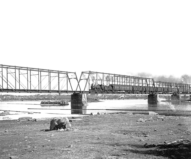
The Prince of Wales Bridge was opened with the Québec, Montréal, Ottawa & Occidental Railway extending its line to the Chaudière yards from Hull.
Railway Companies
- Canadian Pacific Railway
- St. Lawrence & Ottawa Railway
- Canada Atlantic Railway
1883 saw the Canada Atlantic Railway complete a line from Coteau Québec to the Chaudière yards. The first section, terminating at Elgin Street, opened on 13 September 1882. The remaining section of the line was completed in December 1883 to Broad Street.
Railway Companies
- Ottawa, Arnprior & Parry Sound
- Canadian Pacific Railway
- Canada Atlantic Railway
On 18 September 1893, the Ottawa, Arnprior & Parry Sound Railway opened a line from Ottawa to Arnprior. The entire line to Parry Sound was completed by October 1894.
Railway Companies
- Ottawa, Arnprior & Parry Sound
- Canadian Pacific Railway
- Canada Atlantic Railway
Between 1895-1896, the Ottawa, Arnprior & Parry Sound Railway and Canada Atlantic opened a line along the canal toward Rideau Street. The Central Depot was opened on 17 September 1896 at the end of this line.
Railway Companies
- Ottawa, Arnprior & Parry Sound
- Canadian Pacific Railway
- Canada Atlantic Railway
- Ottawa & New York Railway
In 1898, the Ottawa & New York Railway arrived with a new line from Cornwall to Ottawa.
Railway Companies
- Canada Atlantic Railway
- Canadian Pacific Railway
- Ottawa & New York Railway
- Ottawa, Northern & Western Railway
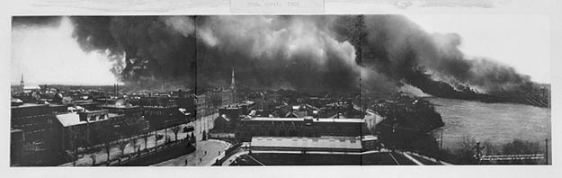
On 26 April 1900, a chimney fire in Hull soon spreaded into a huge conflagration which consumed much of Hull and almost all of Lebreton Flats. The fire took much of the Chaudière yards with about 188 freight cars destroyed and the Canadian Pacific Union Station and freight sheds destroyed as well.
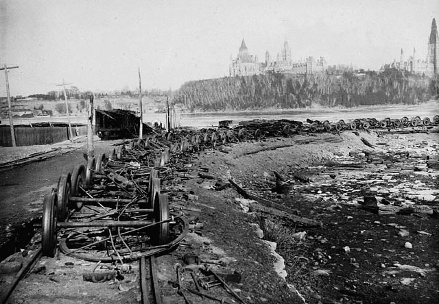
However, the railway and lumber yards in Ottawa quickly recovered and by the end of the year, passenger service resumed to Broad Street with a new Union Station.
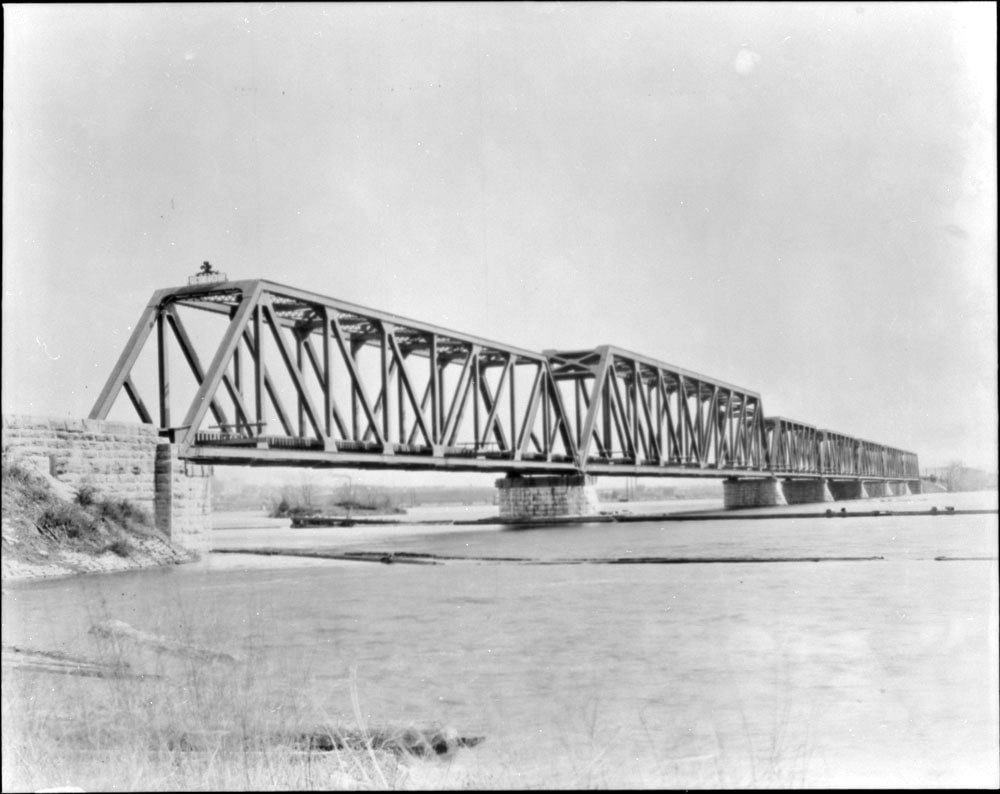
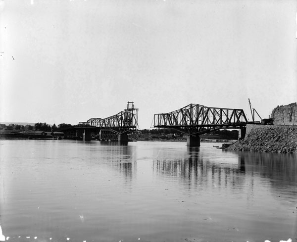
In 1901, the Royal Alexandra Interprovincial Bridge is opened and the first train crossed the bridge on April 22.
Railway Companies
- Grand Trunk Railway
- Canadian Pacific Railway
- Canadian Northern Railway
- New York Central Railway
The Canadian Northern Ontario Railway opened a line from Hawkesbury to Ottawa (at Henderson Avenue) and service commenced between Montreal and Ottawa on 5 December 1909.
Railway Companies
- Grand Trunk Railway
- Canadian Pacific Railway
- Canadian Northern Railway
- New York Central Railway
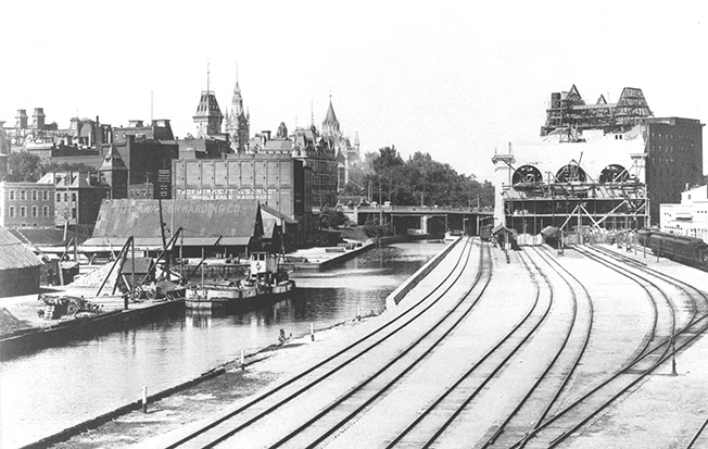
On 1 June 1912, the Grand Trunk Railway (GTR) opened its Central Station (later known as Union Station) along with the its hotel the Chateau Laurier. The grand opening was subdued due to the death of GTR's president Charles Melville Hays on the RMS Titanic on 15 April 1912.
Railway Companies
- Grand Trunk Railway
- Canadian Northern Railway
- Canadian Pacific Railway
- New York Central Railway
The Canadian Northern Ontario Railway opened a line from Napanee to Hurdman on 3 December 1913.
Railway Companies
- Grand Trunk Railway
- Canadian Northern Railway
- Canadian Pacific Railway
- New York Central Railway
The Canadian Northern Ontario Railway opened a line from Pembroke to Ottawa on 23 November 1915.
1915 marked the start of rail's height in Ottawa. Ottawa's rail network would remain this way throughout the 20's and most of the 30's.
Railway Companies
- Canadian National Railway
- Canadian Pacific Railway
- New York Central Railway
The first major railway line abandoned in Ottawa was the Canadian National Railway (originally Canadian Northern Ontario Railway) from Hawkesbury to Hurdman.
Railway Companies
- Canadian National Railway
- Canadian Pacific Railway
- New York Central Railway
A section of the Renfrew line was abandoned from Island Park Drive to a new connection called Nepean Junction (just north of Corkstown Road).
Railway Companies
- Canadian National Railway
- Canadian Pacific Railway
- New York Central Railway
- Joint Trackage
In 1950, Jacques Gréber completed a plan for the National Capital Region which would drive urban planning in the region for the next 50 years. Part of the plan included removing railway lines out of the downtown and into the suburbs.
One of the first steps in the plan was the creation of the Walkley Trainyards. The Walkley Line was opened by Canadian National on 19 November 1953 and most freight was redirected along this line.
Railway Companies
- Canadian National Railway
- Canadian Pacific Railway
- Joint Trackage
On 16 February 1957, New York Central Railroad, that took over the Ottawa & New York Railway, abandoned the line from Ottawa to Cornwall. A short section was retained by Canadian National as the Ramsayville Spur.
Railway Companies
- Canadian National Railway
- Canadian Pacific Railway
- Joint Trackage
In 1960, Canadian National abandoned the section of the Renfrew line between Bayswater Avenue and Preston Street. That same year, the Uplands spur is also abandoned.
Railway Companies
- Canadian National Railway
- Canadian Pacific Railway
- Joint Trackage
The years 1961 and 1962 saw the removal of the Renfrew line from the Rideau Canal to the Chaudière yards.
Railway Companies
- Canadian National Railway
- Canadian Pacific Railway
- Joint Trackage
By 1967, the railway plans of the Gréber Plan were nearing completion as all the railway lines were removed from the downtown and replaced with parkways and expressways.
In 1963, the remaining Renfrew line in the downtown was abandoned.
1966 saw the most significant changes with the following:
- removal of the original Ottawa & Prescott Railway line from Sussex Drive south to Bank Street
- the creation of a Hawthorne Connection just east of Sheffield Road
- the removal of tracks from Hurdman to Union Station along the canal
- the removal of tracks over the Interprovincal Bridge.
Also, a new Ottawa Station was opened on 31 July 1966 near the suburb of Alta Vista. The old Union Station was saved from demolition and became the Government Conference Centre. Currently it houses the Senate while renovations are taking place at the Centre Block of the Parliament Buildings.
By 5 August 1967, the tunnel under Dow's Lake and its below grade approaches were complete.
By 28 August 1967, Canadian Pacific Railway abandoned part of the Carleton Place line from Bells Corners to McRae Avenue.
In October 1967, Canadian Pacific closed the Ottawa West Yard and moved freight to the Walkley Yards.
Railway Companies
- Canadian National Railway
- Canadian Pacific Railway
- Joint Trackage
Canadian Pacific abandoned a section of the Carleton Place Spur between McRae Avenue and Ross Avenue.
Railway Companies
- Canadian National Railway
- Canadian Pacific Railway
- Joint Trackage
Two minor changes occurred in 1972. Canadian Pacific removed a section at Ellwood Junction and the Ramsayville spur was abandoned by Canadian National.
Railway Companies
- Canadian National Railway
- Canadian Pacific Railway
- Joint Trackage
Canadian Pacific removes the last section of the Carleton Place spur between Ross Avenue and Bayview Road.
Railway Companies
- Canadian National Railway
- Canadian Pacific Railway
- Joint Trackage
Canadian Pacific abandoned the last of the Sussex Street line between Bank Street and Ellwood.
Railway Companies
- Canadian National Railway
- Canadian Pacific Railway
- Joint Trackage
On 9 August 1986, Canadian Pacific abandoned the Montréal and Ottawa line between Rigaud and Ottawa.
Railway Companies
- Canadian National Railway
- Canadian Pacific Railway
- Joint Trackage
On 15 January 1990, Canadian Pacific adandoned the Carleton Place line from Nepean to Carleton Place.
Railway Companies
- Ottawa Central Railway
- Via Rail Canada
- Joint Trackage
- Quebec Gatineau
Canadian Pacific abandoned the Ottawa Airport spur this year.
Railway Companies
- Ottawa Central Railway
- Via Rail Canada
- Joint Trackage
- Quebec Gatineau
Canadian Pacific abandoned the Prescott line from Leitrim Road and Kemptville.
Railway Companies
- Ottawa Central Railway
- Via Rail Canada
- O-Train
- Quebec Gatineau
- Joint Trackage
On 15 October 2001, the City of Ottawa began light-rail service along the railway line going under Dow's Lake between Bayview and Greenboro. The new service was called the O-Train.
On July 2002, the tracks for the express sheds at Terminal Avenues were abandoned back to Lancaster Road.
Railway Companies
- Canadian National Railway
- Via Rail Canada
- O-Train
- Gatineau
- Joint Trackage
Canadian National abandoned its railway line from Nepean Junction to Pembroke.
Railway Companies
- Canadian National Railway
- O-Train
- Via Rail Canada
- Joint Trackage
- Gatineau
On September 14, 2019, the Confederation Line of the O-Train opened between Tunney's Pasture Station and Blair Station.
Map created using OpenLayers 4
Ottawa's Railways Through The Years
At the height of rail transportation, most North American cities had extensive railway networks and Ottawa was no exception. Starting with the Bytown and Prescott Railway in 1854, Ottawa's railway network expanded to over 120 km, 2 stations and 3 railway companies by 1930. With the implementation of much of the Greber Plan, Ottawa's railway lines were moved from the downtown to the suburbs and replaced with highways and parkways by the late 1960s. Since then, the city's move from heavy industry to high-tech businesses has seen its railway system diminish to two intercity passenger train lines (to Montreal and Toronto), light rail and one short branch for freight to Arnprior. However, many of the original rights-of-way still exist as pathways, roadways or just abandoned lines.
I created this map to show Ottawa's railway network through the years. Information on the railway lines was gathered using historic topographic maps and air photos from the University of Ottawa and GeoOttawa.